| Date | 13 Oct 2025 |
| Route | Link to Route |
| Distance | 10.30km / 6.40miles |
| Ascent | 822.96m / 2700.00ft |
| Enjoyable | |
| Difficulty | |
| Conditions | Cloud inversion, warm and dry above the clouds |
| Summits | ✔ (M) Fionn Bheinn |
Staying over in Inverness and the Brothers Ridge planned for the next day, we decided to fill our time with a little leg stretcher, Fionn Bheinn. Leaving the house before 6am, we travelled over to Achnasheen, parked at the unmanned railway station around 9:30am. Weather was overcast, and felt like it might rain.
Heading up over the main road, we followed the walkers signs up to the water treatment works, through a gate behind and then followed the grassy path on the east side of the Allt Achadh na Sine stream. Once over a fixed gate, the path steepens and becomes quite wet and muddy in places.
Eventually we saw the water sluice through the mist and lost the path so headed straight though the bog before re-joining the track a short time later. About half a kilometre later we took our first break and encountered a couple we got chatting to for a while, including finding out how steep our ascent was going to be next day!
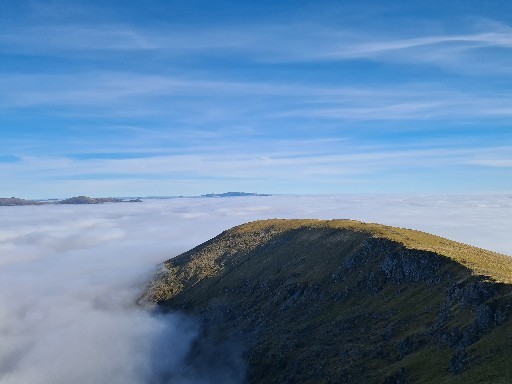
We struck off the path at this point, heading straight up towards the top of Creagan nan Laogh, a little tough in the longer boggy grass, but rewarded towards the top when we stepped out of the mist to a fantastic cloud inversion and a fog bow.
From here we ascended north up to the rocky east end of the main ridge, the path soon disappearing into shorter grass. However, once we gained the ridge we took the well defined path to the west to soon reach the summit of Fionn Bhienn. We chatted to a few more people at the summit as we had lunch taking in the fantastic views of various ranges poking through the clouds from the Fannichs all the way around to the mighty Ben Nevis.
Earlier in the day we heard several gun shots towards the east so we decided to avoid the circuit in the guide books and head back the same route, but noticed a more direct path, avoiding Creagan nan Laogh. So heading back east we descended to the main ridge before turning south, eventually picking up a boggy path towards the top of some streams on the OS map. The path turned out to be the same one we used earlier in the day.
As we neared the sluice, I lost my footing in the mud and made the mistake of not releasing my pole quick enough and ending up bending the middle section, but thankfully still usable. Here's hoping that Black Diamond do replacement parts!
Once back at the car, we were greeted by two trains stopping simultaneously at the station, but we were in the middle of getting changed, so no photos.